About CUT-AIS
CUT-AIS is a ship tracking intelligence platform that uses AIS technology to display vessels in a realtime map and provide information about Ship type, Navigational status information and Voyage-related information.
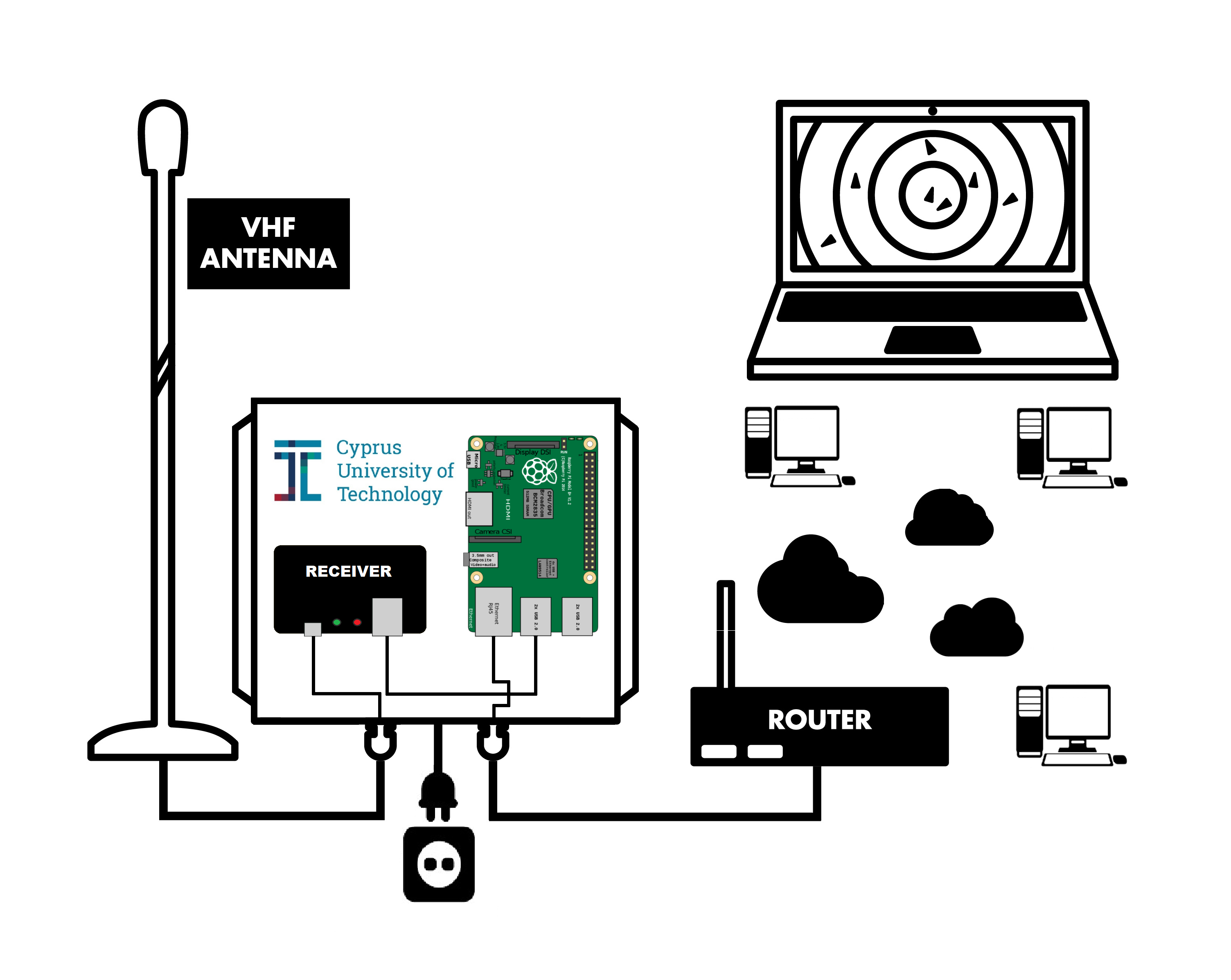
For the implementation, an AIS base station was installed on the roof of the Electrical Engineering Building of the Cyprus University of Technology.
A Raspberry pi 3 was programmed to decode the collected signals from the receiver and to import them into a database hosted at a local Cyprus Univercity of Technology Server. For the Graphic Environment on the map, algorithms were created to display the ships positions and their true directions, polygons that are relevant for the Cyprus Maritime Sector, ships that are moving or stopped and the different types of the ships. In addition, algorithms were created to calculate important parameters such as the Estimated Time of Arrival of ships, The waiting time of the ships at the Anchoring Area and the time of ships stay at the Port Area.
On the website users can find all the above mentioned elements in an integrated system and monitor the calculated statistics informations that are updated daily.

What is an AIS System?
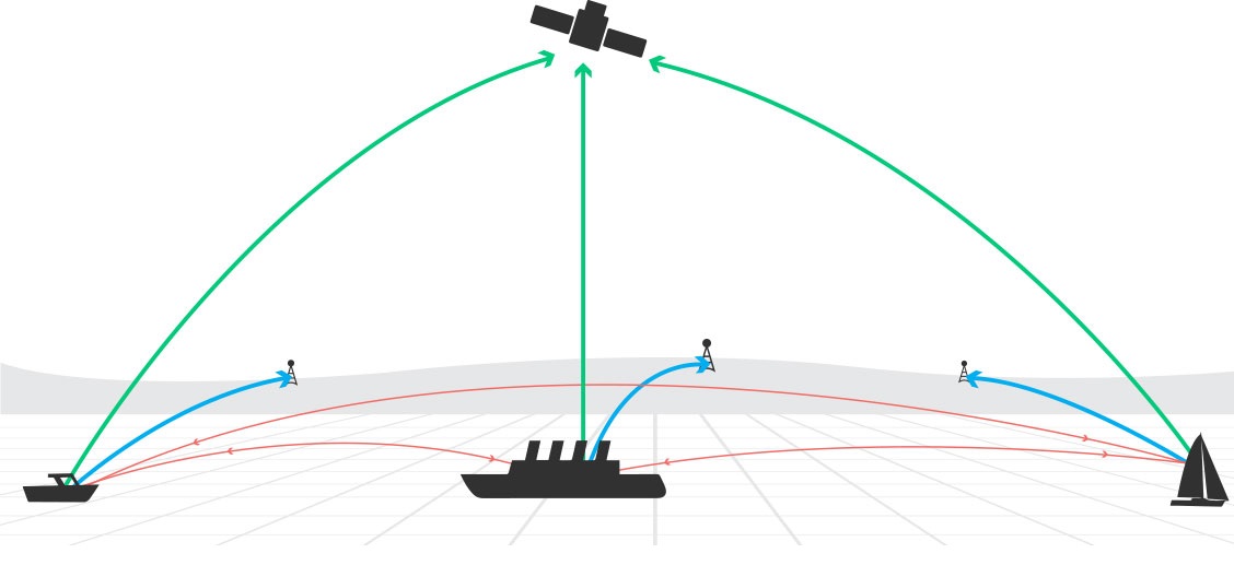
The automatic identification system (AIS) is an automatic tracking system used on ships and by vessel traffic services (VTS). When satellites are used to detect AIS signatures, the term Satellite-AIS (S-AIS) is used. AIS information supplements marine radar, which continues to be the primary method of collision avoidance for water transport.
Information provided by AIS equipment, such as unique identification, position, course, and speed, can be displayed on a screen or an ECDIS. AIS is intended to assist a vessel's watchstanding officers and allow maritime authorities to track and monitor vessel movements. AIS integrates a standardized VHF transceiver with a positioning system such as a GPS receiver, with other electronic navigation sensors, such as a gyrocompass or rate of turn indicator. Vessels fitted with AIS transceivers can be tracked by AIS base stations located along coast lines or, when out of range of terrestrial networks, through a growing number of satellites that are fitted with special AIS receivers which are capable of deconflicting a large number of signatures.
The International Maritime Organization's International Convention for the Safety of Life at Sea requires AIS to be fitted aboard international voyaging ships with 300 or more gross tonnage (GT), and all passenger ships regardless of size. This decision came as a result of the 2002 SOLAS (Safety of Life at Sea) agreement's relative mandate.

How does AIS work?
AIS normally works in an autonomous and continuous mode, regardless of whether it is operating in the open seas or coastal or inland areas. Transmissions use 9.6 kb GMSK FM modulation over 25 or 12.5 kHz channels using HDLC packet protocols. Although only one radio channel is necessary, each station transmits and receives over two radio channels to avoid interference problems, and to allow channels to be shifted without communications loss from other ships. The system provides for automatic contention resolution between itself and other stations, and communications integrity is maintained even in overload situations.
What kind of information is AIS-transmitted?
A switched on onboard AIS transponder keeps transmitting information even when the subject vessel is anchored. The information contained in each AIS-data packet (or message) can be divided into the following two main categories:
Dynamic Information (such information is automatically transmitted every 2 to 10 seconds depending on the vessel's speed and course while underway and every 6 minutes while anchored from vessels equipped with Class A transponders)
- Maritime Mobile Service Identity number (MMSI) - a unique identification number for each vessel station (the vessel's flag can also be deducted from it)
- AIS Navigational Status (read more on the subject)
- Rate of Turn - right or left (0 to 720 degrees per minute)
- Speed over Ground - 0 to 102 knots (0.1-knot resolution)
- Position Coordinates (latitude/longitude - up to 0.0001 minutes accuracy)
- Course over Ground - up to 0.1° relative to true north
- Heading - 0 to 359 degrees
- Bearing at own position - 0 to 359 degrees
- UTC seconds - the seconds field of the UTC time when the subject data-packet was generated.
Static & Voyage related Information (such information is provided by the subject vessel's crew and is transmitted every 6 minutes regardless of the vessel's movement status)
- International Maritime Organisation number (IMO) - note that this number remains the same upon transfer of the subject vessel's registration to another country (flag)
- Call Sign - international radio call sign assigned to the vessel by her country of registry
- Name - up to 20 characters
- Type (or cargo type) - the AIS ID of the subject vessel's shiptype
- Dimensions - approximated to the nearest metre (based on the position of the AIS Station on the vessel)
- Location of the positioning system's antenna on board the vessel
- Type of positioning system (GPS, DGPS, Loran-C)
- Draught - 0.1 to 25.5 metres
- Destination - up to 20 characters
- ETA (estimated time of arrival) - UTC month/date hours:minutes
It is important to notice that the vessel's crew or the accountable vessel's officer should make sure that they provide the system with the correct information regarding all static and voyage-related fields.
Note also that Class B transponders transmit a reduced set of data compared to Class A (IMO number, Draught, Destination, ETA, Rate of Turn, Navigational Status are not included). The reporting intervals from Class B transponders are also scarcer compared to those of Class A transponders (30 seconds minimum).
This platform was designed by:
- Theofilos Onisiforou
- Theofanis Christou
- Elizabeth Pieri
- Lambros Odysseos
- Constantinos Christofi


